

Supporting Information
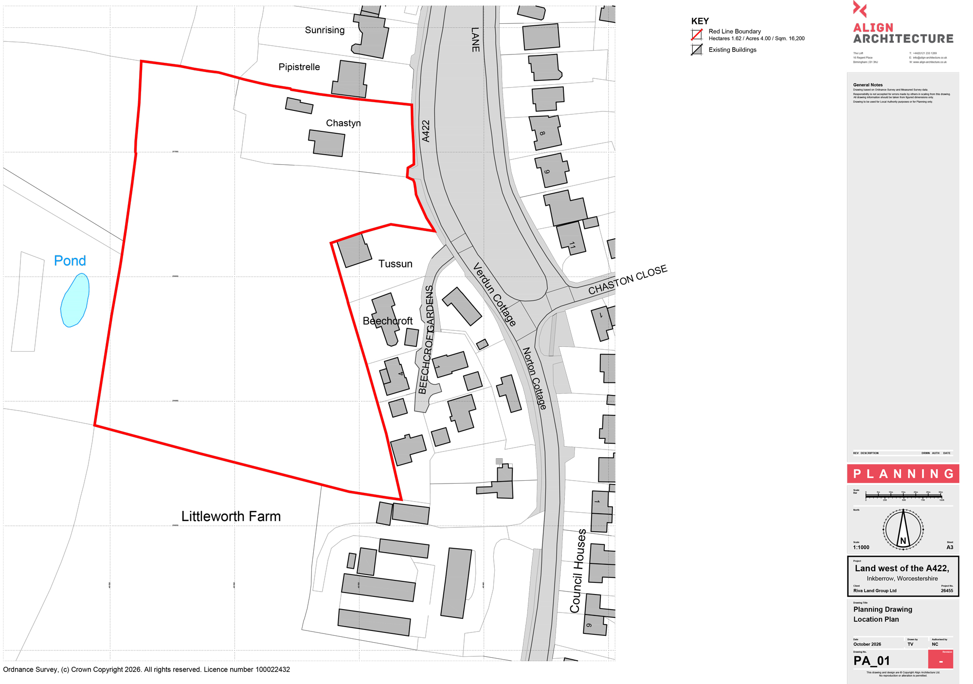
The following supporting information is provided to help to inform a planning application for Inkberrow that is to be lodged in 2026.
Aligned with the Government’s commitment to building 1.5 million homes and objectives of sustainable development, the 1.62ha site at Inkberrow represents an ideal opportunity to deliver much needed homes serving both Inkberrow and the wider Wychavon district area in a sensitive and appropriate location.
Read MoreAligned with the Government’s commitment to building 1.5 million homes and objectives of sustainable development, the 1.62ha site at Inkberrow represents an ideal opportunity to deliver much needed homes serving both Inkberrow and the wider Wychavon district area in a sensitive and appropriate location.
The site is partially within the settlement boundary of Inkberrow (see image below), within easy walking and cycling distance to the villages impressive services and facilities and adjoins modern housing. The site is constraint free, with neither being subject to or adjoining any designated heritage or landscape assets and is also in Flood Zone 1 as defined by the Environment Agency; that is, land least liable to flooding.
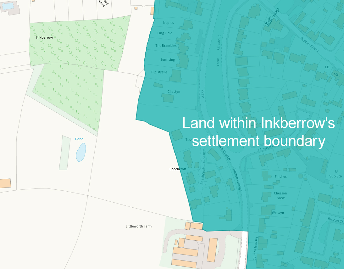
The development is proposed in outline form, however important parameters such as the vehicular access point onto the A422, and amount of housing are defined. Up to 30 houses are proposed, of which 40% will be affordable homes to meet local and district needs. The precise housing mix will be informed by the Council’s housing and policy positions, however it is envisioned a mix of 2, 3, and 4 bedroom dwellings, including bungalows, would form the offer.
The site’s development and amount of houses proposed represents careful study and assessment of its context and setting. 40% of the site (excluding private garden areas) will comprise green infrastructure, with open space, planting, landscaping and a children’s play area proposed. At an overall density of around 19 dwellings per hectare, the development is of a respectful quantum that recognises its edge of village location. This not only ensures a high quality environment for future residents to live in, but also ensures the development is a positive addition to Inkberrow and meets wider Council objectives.
Given the Council’s current housing land supply shortfall, the sustainable and constraint free nature of the site, and wider compliance with national and local planning policies, the proposals represent a sensitively considered development.
The key features and benefits of the proposals include –
· Delivery of new homes adjoining the settlement boundary, close to village facilities, helping Wychavon District Council address their housing land supply position.
• 40% affordable homes to meet significant local and district needs.
• Reuse of the existing Chastyn access to limit tree and hedgerow loss on the A422.
• Use the lower eastern and southern areas for sustainable drainage and open space.
• Strengthening the southern field boundary with a planted edge to the village.
• Retain and enhance existing green infrastructure.
• Biodiversity enhancements.
• Provision of new open space and children’s play area.
Blade landscape consultants have advised the following approach.
Read MoreBlade landscape consultants have advised the following approach.
The site is a greenfield situated outside but neighbouring the settlement boundary from the previously adopted SWDP 2016, and that retained with the recent SDWP Reg 19. The land is not within a national or locally designated landscape, a protected landscape, and is not neighbouring or within the setting of any such sensitivity. The Local Plan or associated SPD does not advocate any special landscape areas, which otherwise elevate the sensitivity of the site. Additionally, with consideration of the 2016 SWDP policies map and also the Reg 19 SWDP Review, the Site is not within a strategic gap, green gap or any similar spatial stand off to restrict development with the aim of maintaining the identity of settlements/prevent coalescence.
There is a conservation area within Inkberrow. However, the Site is not situated within the Conservation Area, or neighbouring it. Given the intervening distance, the main route of the A422, intervening residential including interwar homes as well as the significant trees/tree groups along the A422, the Site has a very limited contribution to the setting the Conservation Area, and from a landscape perspective, the development of this land as proposed for new homes, would not diminish the Conservation Area’s value or integrity.
Given the foregoing, the main consideration here is the character and appearance of the proposal. The main landscape polices within the engaged local planning polices are relatively standard. The 2016 policy requiring that developments ‘take into account the latest Landscape Character Assessment and its guidelines’, and that new development is ‘appropriate to, and integrate with, the character of the landscape setting’ and ‘conserve, and where appropriate, enhance the primary characteristics defined in character assessments and important features of the Land Cover Parcel, and have taken any available opportunity to enhance the landscape’. The SWDP Review judges appropriateness through a similar policy wording.
Given this, we have adopted an approach that ensures that the following matters be considered from a landscape perspective:
Locally, there is a predominance of two storey dwellings, with little 2.5 storeys. We would suggest given the edge of settlement location, that the scheme is retained as two storey with some variance of buildings height – say 8.5 metres and 9.5 metres units – the squashed, low cottage is commonly seen around this part of Worcestershire. 2.5 storey at the odd location may just work, but this would have to be interfacing with the village and any potential effect on the Conservation Area should be thought through.
The layout whilst only parameters plan, has some variance of building limit (and also the aforementioned heights) to step development away from its edges and so create a characterful variance.
Stepping development back from the A422 in the northeast works well and resi curtilages are set well away from the roadway and the general arrangement of green verges and tree groups along this route.
Arrangement of dwellings – the receiving environment has a varied pattern rather than say the dwellings along Stone Pit Lane to the north
Need to strengthen the southern field edge so more resilient containing and limiting the new buildings – this can be done through landscape, and the proposals enable this. Again, some variance of new buildings inside of this is helpful.
The village has a more obvious tree’d character to the east and south and the land is situated within this soft setting. therefore, tree planting within the scheme outside of the POS and within the NDA would be ideal.
The route of the A422 has an informal tree’d character. I would recommend tree retention or opportunities to replace at this curtilage too, so offsetting the effect of the new access/egress point. The combination of this, setting new built form away from this edge, and a variation in building heights and limiting 2.5 storey so it is experienced form this northeastern edge would offset and reduce the effects on the roadway, the entrance to the village and the village setting of the Conservation Area.
A full topographical and tree survey has been carried out on the site. The existing tree stock is of fairly low quality but T21 (Walnut) on the northern boundary and T9 (Sycamore) on the southwest boundary of the site, deserve some respect and space within the layout.
Read MoreA full topographical and tree survey has been carried out on the site. The existing tree stock is of fairly low quality but T21 (Walnut) on the northern boundary and T9 (Sycamore) on the southwest boundary of the site, deserve some respect and space within the layout.
The site will afford additional planting to streets and open spaces with suitable species once the scheme has been progressed further.
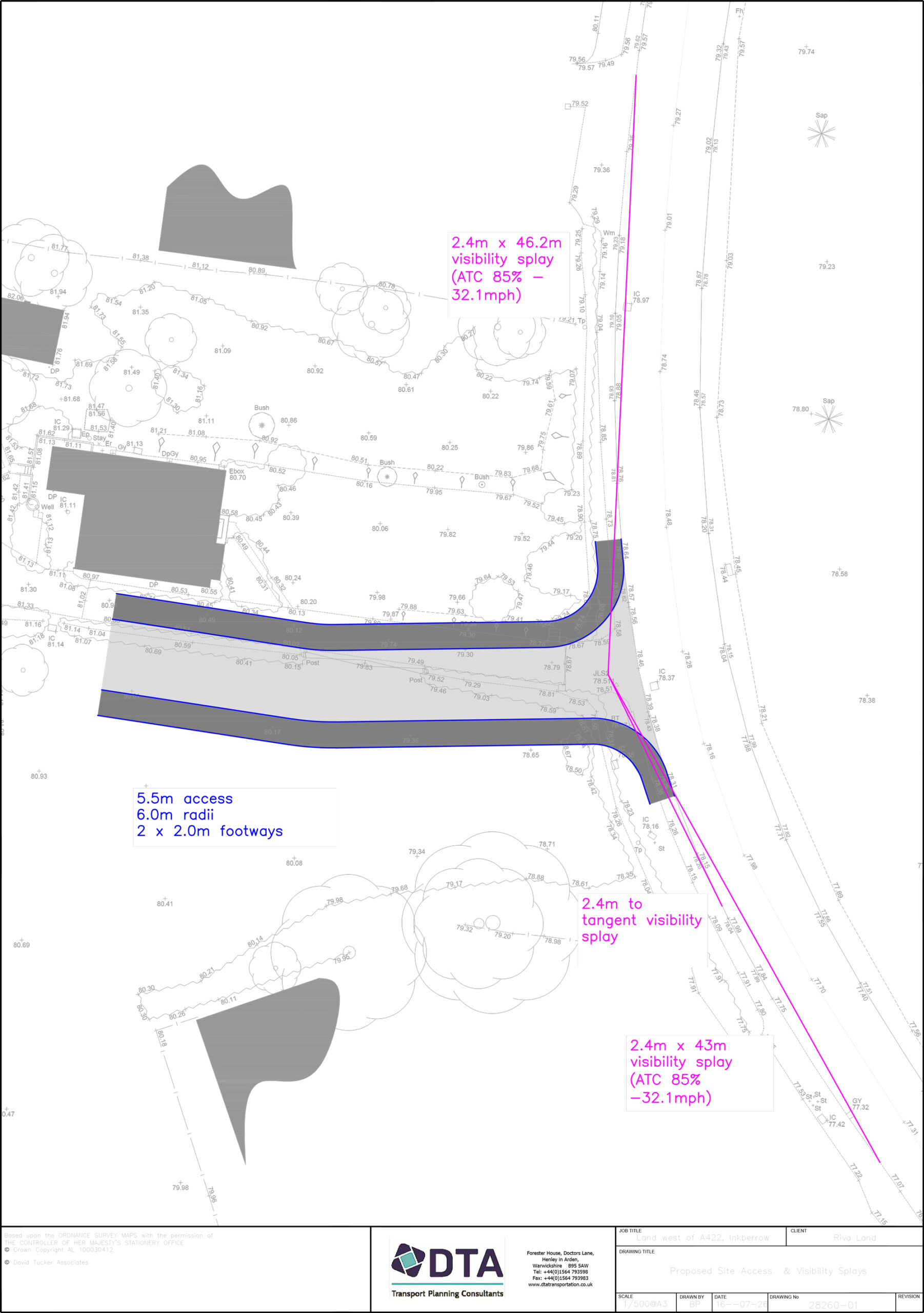
A suitable access has been designed in accordance with WCC’s design requirements to accommodate a development of approximately 30 dwellings that would have no material impact on the A422. The visibility splays have been informed by recorded traffic data and a safety audit will be undertaken with any recommendations being incorporated into the design.
Read MoreA suitable access has been designed in accordance with WCC’s design requirements to accommodate a development of approximately 30 dwellings that would have no material impact on the A422. The visibility splays have been informed by recorded traffic data and a safety audit will be undertaken with any recommendations being incorporated into the design.
There are also various local facilities that are accessible on foot within reasonable walking distance.
Access Drawing:
A phase 1 survey has been completed by G&J Environmental.
Read MoreA phase 1 survey has been completed by G&J Environmental.
Based on the information reviewed during this survey, the risks from land contamination (except those to construction workers) are considered to be low to very low. The risks reflect the overall low potential for significant contamination to be present based on observations made during the site walkover, the site history, and the sensitivity of the proposed development. There is no evidence to suggest the presence of significant contamination on the site, although there is always a possibility of unexpected contamination as a result of undocumented activities, while minor contamination may be present associated with the agricultural and residential uses. A further phase 2 report will establish this at a later date.
This historic environment desk-based assessment considers Land west of the A422, Inkberrow, Wychavon District, Worcestershire (hereinafter referred to as the ‘study site’). In accordance with government policy (National Planning Policy Framework 2024), this assessment draws together the available archaeological, historic, topographic and land-use information in order to clarify the heritage significance and archaeological potential of the study site.
Read MoreThis historic environment desk-based assessment considers Land west of the A422, Inkberrow, Wychavon District, Worcestershire (hereinafter referred to as the ‘study site’). In accordance with government policy (National Planning Policy Framework 2024), this assessment draws together the available archaeological, historic, topographic and land-use information in order to clarify the heritage significance and archaeological potential of the study site.
Archaeology
A review of the available evidence indicates that there is a known potential for remains of two buildings depicted on early 19th century mapping in the study site’s southeastern area, with an otherwise low potential for archaeological remains from all past periods to be present within the study site. Should archaeological remains be present, these are thought to be associated with past agricultural practices and would likely be of no more than Local Significance. A review of lidar imagery has shown a possible sub-rectangular ditched feature near the study site’s centre, for which an archaeological origin cannot currently be ruled out. Remains of National Significance are not anticipated to be present within the study site.
Where known and hitherto unknown archaeological remains are located within the developable land, construction of the scheme will impact upon them. However, the available evidence indicates that archaeological assets are unlikely to represent a design constraint and do not represent a constraint for the proposed development of the study site. A programme of further investigations is likely to be requested by the LPA’s archaeological advisor. A condition attached to the planning permission, requiring further investigation in the form of a geophysical survey and an archaeological trial trenching evaluation would allow an appropriate strategy for the recording of archaeological remains. Depending on results, this may be followed by a further stage of archaeological mitigation, to be agreed with the LPA’s archaeological advisor.
This assessment has not identified any Scheduled Monuments which will be negatively impacted by the proposed development.
Built Heritage
In principle, the proposed residential development of the study site would give rise to a level of less than substantial harm to the significance of the Inkberrow Conservation Area owing to the loss of the undeveloped character of land within the wider rural setting of the conservation area. However, as the study site makes only a minor contribution to the conservation area’s overall significance, and the proposed development would be well-screened from within the historic core of settlement, any less than substantial harm arising from the proposed development would be in the lowest ranges. This is subject to the sensitive height and siting of residential units in the north and west of the study site to ensure there is no visual intrusion on the experience of the conservation area from within its surroundings.
The assessments within this report demonstrate that the proposed development would not have a harmful effect on the following Grade II listed buildings: Inteberga (NHLE 1179856); Bull Farm Cottages (NHLE 1301762); The White House (NHLE 1350244); and The Old Shop (NHLE 1179848).
The assessments within this report also demonstrate that the indicative proposed development would not have a harmful effect on the non-designated Verdun Cottage, centred at SP 01392 56940, or the non-designated Littleworth Farmhouse, centred at SP 01411 56868.
The site area is dominated by low-quality neutral grassland, with a small area of Prunus scrub. Additional habitats on site include the existing bungalow and associated hardstanding and gardens which are of limited ecological value.
Read MoreThe site area is dominated by low-quality neutral grassland, with a small area of Prunus scrub. Additional habitats on site include the existing bungalow and associated hardstanding and gardens which are of limited ecological value.
The retained boundary habitats will maintain commuting, foraging and breeding opportunities for a range of species including bats, birds and reptiles, whilst the proposed habitat creation will provide enhanced opportunities in the long term.
As part of the proposals, the application will secure a minimum of +10% bio-diversity net gain. This is measured from it’s existing to condition to post-development This requirement is now enshrined in planning and the application will demonstrate how this is secured.
Proposed Surface Water Strategy
Read MoreProposed Surface Water Strategy
Available evidence suggests infiltration may be a viable option to drain down the surface water for the site. It is proposed to attenuate surface water on site via. a series of ponds to then infiltrate to below ground level. Upstream of the main sewer network it is proposed to utilize permeable paving and waterbutts for the capture and management of the everyday rainfall noted as the first 5mm of rainfall.
Proposed Foul Water Strategy
All dwellings to discharge to gravity foul water sewer. There is a public foul sewer within the A422 that will be the proposed outfall location for the site.
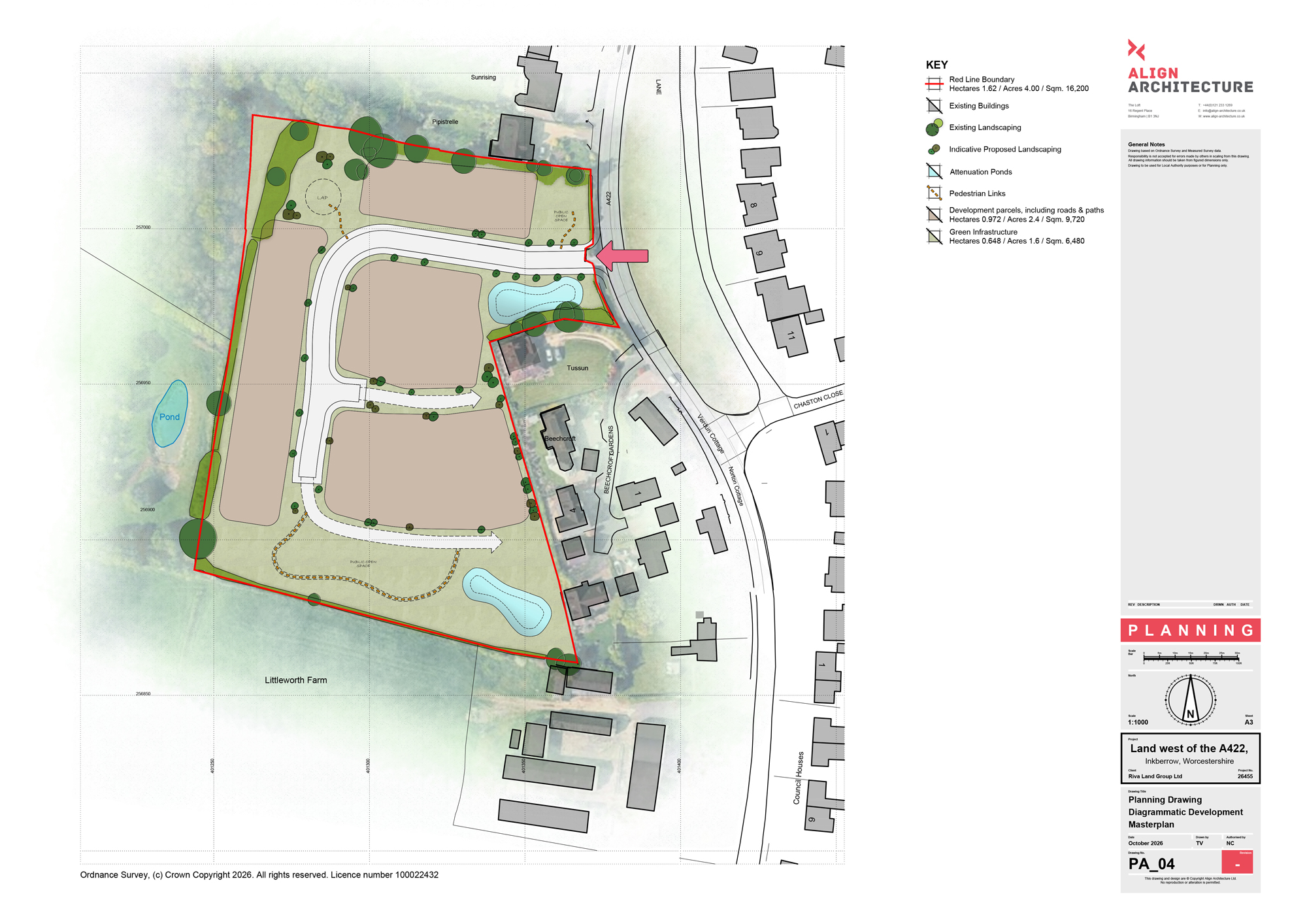
The presented application is for up to 30 residential dwellings with associated access, parking, open space and drainage, as shown on the Diagrammatic Development Masterplan (PA_04).
Read MoreThe presented application is for up to 30 residential dwellings with associated access, parking, open space and drainage, as shown on the Diagrammatic Development Masterplan (PA_04).
Proposal Details
• Existing bungalow (Chastyn) and garage demolished
• Single access from the A422 at the north-east corner
• Development parcels: 0.972ha (60% of the site)
• Green infrastructure: 0.648ha (40% of the site, excluding private gardens), meeting Policy SWDPR 07
• Homes set back from the A422 behind open space and an attenuation pond
• Open space, attenuation pond and footpath links to the southern edge
• Play area and tree-screened buffer to the north-west
Built form is kept to the north and centre of the site, with boundary trees and hedgerows retained and reinforced.
The proposal is for an outline application to be submitted for up to 30 dwellings, on 4 acres of land. This is at what can be considered a low density of 7.5 dwellings / acre, which reflects the sites edge of settlement location.
The proposals will incorporate 40% affordable housing and 40% green infrastructure. A range of dwelling types will be provided including 1-3 bedroom affordable homes (rented and shared ownership) and 2-4 bedroom private housing. Up to 4 bungalows are also proposed within the housing mix.
Scale
• Predominantly two storey housing, reflecting the village edge.
• Lower units, including bungalows, on the higher ground to the north-west.
• Varied building heights and building lines to give a broken roofscape.
• Built form set back from the A422 and from the southern boundary.